*Planes, S, Jones GP, Thorrold SR (2009) Larval dispersal connects fish populations in a network of marine reserves. PNAS 106(14): 5693-5697. 
This map, entitled Franko's Map of Los Angeles County, represents what I like to think of as a "diver's view" of the Los Angeles Area. I own this map and it can be found online at the following website: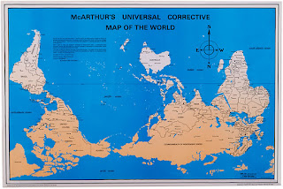

This map, entitled Franko's Map of Los Angeles County, represents what I like to think of as a "diver's view" of the Los Angeles Area. I own this map and it can be found online at the following website:
http://frankosmaps.com/maps/product/Frankos-Map-of-Los-Angeles-County-Coast.html
This map is a colorful representation of some of the most popular and also not well known dive spots that can be found off the coast of Los Angeles. The map describes different aspects of the dive sites shown from Ventura County line to Palos Verdes Peninsula. This map also depicts some of the fish that can be seen while diving in this area. I am a frequent user of the map, as I love to dive, and I have found that it does not often lead me astray.

The map shown below is called, "McArthur's Universal Corrective Map of the World". The map was found on the following webpage:

The map shown below is called, "McArthur's Universal Corrective Map of the World". The map was found on the following webpage:
http://www.odtmaps.com/detail.asp_Q_product_id_E_McA-23x35
The map offers a perspective on the world different from the "north-centric" or "euro-centric" view typically presented. Stuart McArthur made this map when he was 12 years old because he lived in Australia and had a different perspective on the world. I think this map is interesting because the "normal" view of the world with the north at the top of the map is completely arbitrary. This view apparently only came about because European navigators used the north star and a magnetic compass to navigate.

No comments:
Post a Comment